NbS Long list
Below, we have listed the NbS solutions for the Mekong Subregion based on our experience in the basin and the supportive information and literature collected from multiple sources. From this longlist, we have shortlisted high-potential nature-based solutions that are used as case studies, which were further analysed for their upscaling potential.
Protect and rehabilitate existing wetlands
Benefits
-
Mitigate floods by capturing, buffering, reducing the velocity and the amount of peak flow.
-
Improve water quality and act as natural sediment traps with the slow flow of water through wetland vegetation, promoting sediment deposition thus balancing land subsidence in the face of rising seas.
-
Reduce the excess salt and pest in the land.
NbS Measures
1a. Natural inland wetlands

Source: NbS catalogue (World Bank, 2021)
The aim is to improve or restore the natural connectivity between the river channels and the floodplains. Reactivating wetland areas would improve its environmental performance and overall resilience of the river system.
1b. Drainage reduction
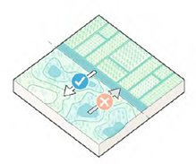
Source: NbS catalogue (World Bank, 2021)
Natural inland wetland areas have been used for agriculture in many regions around the world. To make the land suitable for crops, drainage systems are installed to control the water table and provide irrigation.
To reverse the destruction of the wetland, natural water fluctuation must be restored together with the composition of the anaerobic hydric soil formed over a long period. The first step is to remove a section of the underground agricultural tile that is draining the wetland basin or create a ditch plug by building an earthen wall to impound water.
Inspiration maybe be found in the cased of traditional Khmer agriculture system that enhanced both water and sediment natural cycles to irrigate and create soil texture suitable for different crops (Delvert 1961; L’Hamarttan1994).
Rehabilitate, restore, and enhance natural floodplain dynamics
Benefits
-
Reduce flood risk.
-
Act as a protective buffer and store the water overflow from the river during a flood and slowly release the water back.
-
Riparian and floodplain forests control river temperature preserving aquatic flora and fauna.
-
Improve water quality, reduce environmental pollution, facilitate sediment transport and storage, and mitigates soil erosion
-
Serve as an extensive agricultural development in certain cultures, offering a wide option of natural resources to local communities
NbS Measures
2a. Setting levees back

Source: NbS catalogue (World Bank, 2021)
Levee setback is the process of relocating a levee further back in the floodplain to provide extra space for the river to flood. Levee setback provides the river with more floodplain area to interact with and can result in lower flood elevation.
The new space for the river allows new ecological and recreational activities and provides a greater diversity of floodplain habitats. In addition, this new space could also be used as natural resource production, such as agriculture.
2b. River bypass or Oxbow

Source: NbS catalogue (World Bank, 2021)
An oxbow is a historical river meander that is cut off from the main channel during the natural process of channel migration, or through man-made channelization. Water levels are maintained through larger flooding events overflowing into the oxbow and groundwater seepage.
Based on the habitat proposed, inlet and outlet structures may need to be constructed to regulate the inflow and outflow of water for the oxbow.
2c. Re-activating the floodplain

Source: NbS catalogue (World Bank, 2021)
In incised floodplains, a new meandering stream channel is excavated on the original floodplain by raising the stream bed elevation. The former incised channel is then filled, converting it to a floodplain feature. This approach is used in areas where there are few lateral constraints and where flooding on the adjacent land can be increased.
2d. Flood control basins utilising existing embankment system
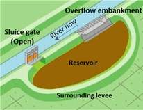
The existing levee/embankment system can be utilised to create flood control basins for water retention (during discharge peaks), or to create additional flow-paths during predetermined discharge conditions. Flood-control basins are facilities that temporarily store river water in adjacent reservoirs to mitigate flood peaks and gradually drain the water back to the main channels after a flood (Ishiyama et al., 2019).
In some of the embankments (in Vietnam) are already sluices present. In others, they can be created, or an overflowing embankment can be implemented to increase connectivity between the floodplain and the main river.
Pollution management, water and flood management
Benefits
-
Trap and break down common pollutants.
-
Improve water quality in surrounding water bodies.
-
Reduce stormwater runoff rates and flood prevention.
-
Recharge surrounding groundwater which will over time become available for use again.
-
Provide habitat for aquatic and other wildlife, including species that can contribute to livelihoods
NbS Measures
3a. Bioswales and rain garden

Source: NbS catalogue (World Bank, 2021)
Bioswales and rain gardens are shallow, densely vegetated ground depressions, with a variety of trees, shrubs, and grasses to collect stormwater from adjacent impervious surfaces
During storms, they become flooded and facilitate ground infiltration and cleaning of stormwater simultaneously. During dry seasons, swales and rain gardens contribute to the quality of public areas. Bioswales are common in streets and other linear infrastructure; rain gardens are common in parks, squares, and private gardens.
3b. Detention pond
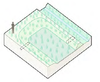
Source: NbS catalogue (World Bank, 2021)
Detention ponds are deeper and less biologically diverse bioretention areas than bioswales and rain gardens. Bioretention systems capture and temporally store stormwater during periods of heavy rain (Eisenberg and Polcher 2020).
Detention ponds can be completely filled with water during storms; they infiltrate much of it into the ground; and discharge the overflow into the sewer system. The remainder of the time they remain dry.
3c. Bioretention pond
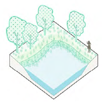
Source: NbS catalogue (World Bank, 2021)
Retention ponds are bioretention areas characterized by a permanent body of water and vegetated edges. Unlike detention ponds, they are permanently filled with water. Retention ponds collect stormwater from the surrounding areas; add storage capacity and ease the pressure on the surface water treatment and sewerage systems.
Retention ponds offer the added benefit of storing water for further reuse during drought conditions, while simultaneously providing habitat and enriching the diversity of public green spaces (Iwaszuk et al. 2019).
3d. Flood-based agriculture

Source: NbS catalogue (World Bank, 2021)
Flood-based agriculture is a traditional farming practice that harnesses seasonal floods in specific regions. It relies on the natural flooding and recession of rivers, lakes, or floodplains to cultivate crops. This approach reduces flood risks and helps replenish the essential fertile sediments crucial for agricultural productivity.
River and stream renaturation
Benefits
-
Protect area from floods by increasing the capacity of waterbodies to hold excessive amounts of stormwater.
-
Reduce river floods by creating water retention and infiltration capacity in the river system.
-
River and stream renaturation can decrease pollution of water, soil, and air, stabilize soils and reduce soil erosion, and offset the loss of biodiversity by becoming critical conduits for the movement and propagation of biota.
-
The growing aquatic vegetation creates a conducive environment for fish spawning.
NbS Measures
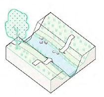
4a. Bank and bed renaturation
Source: NbS catalogue (World Bank, 2021)
The riverbank is an interface of aquatic and terrestrial ecosystems, an area protecting cities from riverine floods and often an important social place with recreational and cultural value. Its renaturation design should also safeguard ecological functions and flood control.
Riverbank and bed renaturation aim to restore the natural dynamic of the river, which may mean restoring its shape, creating natural/physical structures to direct the flow of water, and provide habitat for aquatic species.
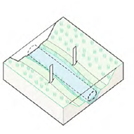
4b. Stream daylighting
Source: NbS catalogue (World Bank, 2021)
Small streams provide a wide array of benefits to communities, such as nutrient and pollution removal, groundwater recharge, and flood mitigation. In some urban areas, streams were previously enclosed by concrete pipes or simply filled in. This could lead to floods, riverbed incision and consequently to severe damages such as building collapses
Daylighting is a technique to remove layers of concrete and recreate the natural shape and dynamic of streams, resulting in increased wildlife and aquatic habitat, and better regulated stormwater runoff treatment and intake (Eisenbert and Polcher, 2020).
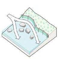
4c. Bioengineering techniques
Source: NbS catalogue (World Bank, 2021)
Renaturation relies on several bioengineering techniques to recreate the natural course of a river and connect it to its landscape for floodplain and riparian corridor revegetation, riverbank stabilization, and restoration of the riverbed.
The natural river dynamic rests on the use of plants, rocks, and other natural elements, as well as geotextiles and membranes to create ecologically rich and structurally stable environment mimicking natural conditions, while providing space for recreation (Eisenbert and Polcher, 2020).
Water and flood management
Benefits
-
Improved drainage during minor and major storms.
-
Reduced flooding.
-
Natural stormwater and pollution filtration.
-
Increased habitat for native plant and animal species. Improved flow, which reduces stagnant water and associated odour and disease vectors.
NbS Measures
5a. Drainage corridors
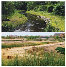
Creating natural drainage corridors normally involves converting a ditch or storm drain into a natural creek flowing within a multipurpose corridor. They can also be created by rehabilitating and enhancing natural creeks and streams. They greatly reduce the number of drainpipes and other costly technologies required to manage stormwater runoff, and they reduce flood management costs overall.
Stormwater is collected in a traditional pit and pipe network within the road reserves. The pit and pipe network conveys flows to the drainage corridor where wetland conditions treat runoff before discharging to the natural watercourse.
Slope stabilization
Benefits
-
Reduces length and steepness of the slope.
-
Provides stable areas for establishment of other vegetation such as trees and shrubs.
-
Provides immediate slope stabilization and helps to retain sediment and prevent soil degradation.
-
Log terracing near the river has the potential to support agriculture. By creating terraces using logs or other materials, farmers can effectively manage soil erosion and water runoff.
-
Can improve aesthetics and provide wildlife habitat.
-
Live stakes are an effective method for introducing a specific plant species for food sources to a site that has the potential to be developed as a small-scale community plantation area.
-
Slows the flow of water in high water stages.
-
Staking a streambank helps dry out a wet, unstable bank and allows it to become more stable.
NbS Measures
6a. Log terracing
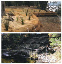
Log terracing is a way to intercept water running down a slope and comprises bedding logs or coir logs in shallow trenches along the corridor. Log terracing is used on burned slopes that have less than 30% of the original ground cover remaining and are at risk of increased erosion, and where there are enough logs of adequate size to construct a semicontinuous line at the desired horizontal spacing. It is better to use coir logs made locally, than to fell trees
Log terracing shortens the slope length and the gradient between each structure, providing stable planting areas throughout most of the slope face. Logs must be installed in trenches and staked into place.
6b. Live staking
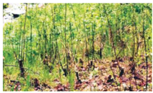
Live staking and joint planting involve the insertion of woody shrub cuttings into the ground in a manner that allows the cutting (stake) to take root and grow. Live stake cuttings can be used to repair small earth slips and slumps. The stakes can help buttress the soil and arching
Nature restoration
Benefits
-
Provide stability and protection against erosion to the riverbank.
-
Improve water quality for downstream rivers and lakes.
-
Support the aquatic invertebrate community, which acts as an important food source for fish.
-
Mitigate the magnitude of flood events, which may be useful to save the Mekong flooded forest.
NbS Measures
7a. Rehabilitate: Riparian silviculture

Silviculture treatments aim to restore riparian areas by replanting trees and vegetation, often with protection from further harvest or removal. These treatments, including thinning, girding, pruning, and coppicing, are used to enhance riparian conditions. The ultimate goal is to establish a riparian buffer zone that can effectively mitigate flooding and erosion, stabilize riverbanks, and preserve the essential connection between the forest and the water system (Gashaw, 2015).
7b. Active restoration
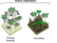
Active restoration involves planting native species to ensure their successful growth. This revival is achieved through sowing seeds or planting seedlings. Sometimes, protection from herbivores, like fencing, may be necessary. It is crucial to remove invasive species beforehand to prevent their return and disrupt the restoration efforts. Starting restoration upstream and progressing downstream can help prevent invasive species from hindering the restoration process. This measure is particularly suitable in areas where the river's physical processes have been significantly altered by human activities, such as dams, levees, bank stabilization, and water diversions (Griggs, 2009).
7c. Passive restoration
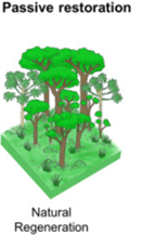
Passive restoration relies on natural generation and requires minimal human disturbance for successful outcomes. This method encourages natural processes like flooding and seed dispersal. Over time, native plants recolonize the area, and the ecosystem regains its functionality. Monitoring the progress of natural regeneration is vital to ensure success. Passive restoration is particularly effective in climates and soil conditions with inherent resilience, such as relatively healthy soil and wetter climates. In arid climates, recovery may take longer (Eubanks, 2004).