Methodology technical feasibility NbS 3
The objective of this map is to showcase which wetlands are suitable for reconnection with the main river. Our methodology for analysing suitable wetlands is based on two guiding principles:
-
Suitable wetlands should show signs of water stress/deterioration and reconnecting the wetland to the river may reverse (part) of the deterioration process.
-
The degree of difficulty of reconnection further determines the suitability. For example, if the distance between the wetland and the river is large, the required investment for reconnection may become prohibitive.
Approach
The spatial potential of the selected NbS types is mapped by overlaying different geospatial datasets, like hydrologic, soil, climatic data. This provides a first high-level indication to the effective geographic scalability of NbS. The suitability for a specific NbS is, where possible, classified in 4 classes: highly suitable, moderately suitable, marginally suitable and not suitable.

Each suitability factor dataset was scored using the following classification:
-
Score of 0: Not a suitable area given the specific suitability factor
-
Score of 1: Moderately suitable given the specific suitability factor
-
Score of 2: Highly suitable given the specific suitability factor
After classifying each individual suitability factor, an aggregated suitability score was calculated by summing up all the scores to yield a single aggregated total suitability score. The suitability class - highly, moderately or marginally suitable, thus depends on the aggregate suitability score of all factors.
Furthermore, should any of the factors render an area unsuitable (score 0), regardless of the scores from other factors, the area is automatically labelled as unsuitable.
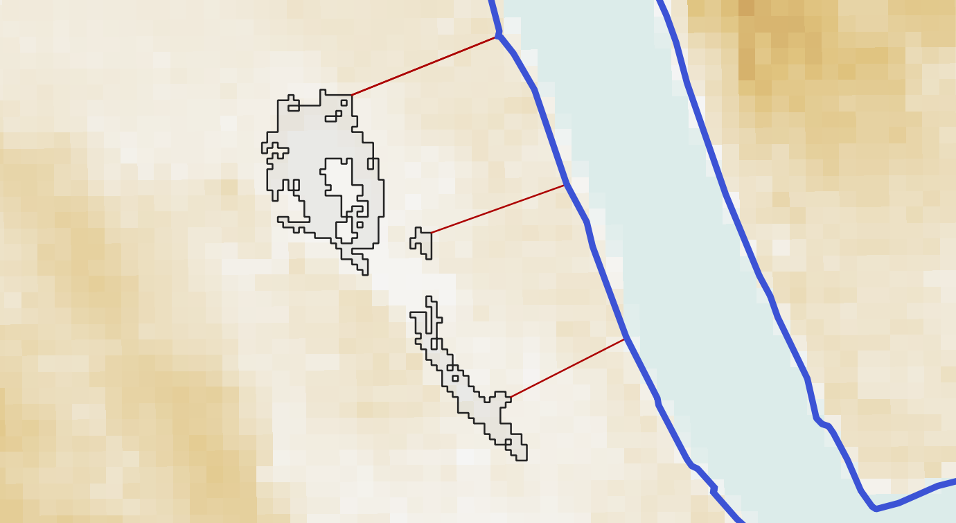
Suitability components for reconnecting wetlands to the river
To assess the potential suitability for reconnecting riverine wetlands four suitability factors were combined.
Relative height of wetland
The potential for reconnecting a riverine wetland partially depends on the relative elevation of the wetland in comparison to the river's elevation. Wetlands that are situated significantly higher than the nearest river are not suitable for reconnection.
Water stress
Disconnected wetlands are, for the purpose of this study, defined as wetlands that show signs of water stress, i.e., a shortage or deficit of water, either due to natural factors such as drought or human-induced causes like overuse of water resources.
Distance to the river
Wetlands in close approximation to a river are generally easier to reconnect and therefore also more suitable to reconnect.
Size of wetland
Larger wetlands are better suited for wetland reconnection Nature-based Solutions (NbS), because reconnecting larger wetlands yields a more substantial impact.
Suitability factor 1: Relative height of a wetland
The median elevation was calculated for each wetland area. Additionally, the median elevation of the river was determined at the buffered endpoint of the shortest line connecting the wetland to the river. The relative height of a wetland was then computed by subtracting the median elevation of the wetland and the median elevation of the river point closest to the wetland.
The following classification system was used:
-
Highly suitable: The wetland is elevated less than 10 meters above the nearest river.1
-
Moderately suitable : The wetland is elevated more than 10 meters but no more than 25 meters above the nearest river
-
Not suitable: The wetland is elevated more than 25 meter above the nearest river
- 1 The global digital elevation model used as input has a vertical accuracy bias, especially in wetland areas with vegetation. Consequently, these wetlands may tend to have a higher elevation in the digital elevation model as compared to the actual elevation. 10 meters was therefore selected as a threshold, although it is on the upper end.
Suitability factor 2: Water stress
Disconnected wetlands are, for the purpose of this study, defined as wetlands that show signs of water stress, i.e., a shortage or deficit of water, either due to disconnection with the main river or other factors such as drought or human-induced causes like overuse of water resources.
To compute which wetlands show signs of water stress we utilised the Water Occurrence Change Intensity product from the Global Surface Water Explorer. This product shows where surface water occurrence increased, decreased or remained invariant between 1984 and 2021. For each wetland we calculated the percentage of area that shows a decrease of surface water. The following classification system was used:
-
Highly suitable: The wetland shows signs of severe water stress, with more than 20% of the wetland area showing a decreasing trend in surface water occurrence.
-
Moderately suitable: The wetland shows signs of water stress, with 5 to 20% of the wetland area showing a decreasing trend in surface water occurrence.
-
Not suitable: The wetland has no water stress, with less than 5% of the wetland area showing a decreasing trend in surface water occurrence.
Suitability factor 3: Distance to the river
For each wetland area, the shortest distance to the river was calculated. The following classification system was used:
-
Highly suitable: The wetland is located less than 2.5 kilometers from the river and the investment to reconnect this wetland to the river is limited.
-
Moderately suitable: The wetland is located between 2.5 and 5 kilometers from the river and the investment needed to reconnect this wetland to the river is moderate.
-
Not suitable: The wetland is located more than 5 kilometres for a river branch and the investment needed to reconnect this wetland may be high.
Suitability factor 4: Size of wetland
The size of each wetland was calculated. The following classification system was used:
-
Highly suitable: The wetland is larger than 3 square kilometers and reconnecting this wetland has a significant impact.
-
Moderately suitable: The wetland is between 0.5 and 3 square kilometers and reconnecting this wetland has an impact.
-
Not suitable: The wetland is smaller than 0.5 square kilometers and reconnecting this wetland has no significant impact.
Suitability factors classification, score and sources
Suitability factors classification scheme
The table below describes the classification scheme used per suitability factors.
No. | Component | Code | Classification |
1 | Relative height of Wetland (H) | H1 | <10 meters height difference |
H2 | 10 - 25 meters height difference | ||
H3 | > 25 meters height difference | ||
2 | Water stress (W) | W1 | > 20 % of wetland area shows a decreasing trend in surface water occurance |
W2 | 5 - 20 % of wetland area shows a decreasing trend in surface water occurance | ||
W3 | < 5 % of wetland area shows a decreasing trend in surface water occurance | ||
3 | Distance to river (D) | D1 | < 2.5 km from the river |
D2 | 2.5 - 5 km from the river | ||
D3 | > 5 km from the river | ||
4 | Size of wetland (S) | S1 | > 3 km2 |
S2 | 0.5 - 3 km2 | ||
S3 | <0.5 km2 |
Suitability scoring scheme
The table below describes the scoring used per suitability factor.
No. | Component | Highly suitable (Score = 2) | Moderatly suitable (Score = 1) | Not suitable (Score = 0) |
1 | Relative height of Wetland (H) | H1 | H2 | H3 |
2 | Water stress (W) | W1 | W2 | W3 |
3 | Distance to river (D) | D1 | D2 | D3 |
4 | Size of wetland (S) | S1 | S2 | S3 |
Suitability factors sources
The table below describes the data source per suitability factor.
No. | Data type | Data source | Data description | Data type |
1 | Wetland database | Zhang, X., Liu, L., Zhao, T., Chen, X., Lin, S., Wang, J., Mi, J., and Liu, W.: GWL_FCS30: a global 30 m wetland map with a fine classification system using multi-sourced and time-series remote sensing imagery in 2020, Earth Syst. Sci. Data, 15, 265–293, https://doi.org/10.5194/essd-15-265-2023, 2023. | In this study, the Landsat reflectance and Sentinel-1 SAR time-series imagery, together with the stratified classification strategy and local adaptive random forest classification algorithm, was successfully integrated to produce the first global 30 m wetland product with a fine classification system in 2020. The wetlands were classified as four inland wetlands (swamp, marsh, flooded flat and saline) and three coastal tidal wetlands (mangrove, salt marsh and tidal flat). | Raster (30x30 m) |
2 | Water occurrence change | Pekel, JF., Cottam, A., Gorelick, N. et al. High-resolution mapping of global surface water and its long-term changes. Nature 540, 418–422 (2016). https://doi.org/10.1038/nature20584 | The Water Occurrence Change Intensity product shows where surface water occurrence increased, decreased or remained invariant between 1984 and 2021. Both the direction of change (i.e. increase, decrease or no change) and its intensity are documented. | Raster (30x30 m) |
3 | Mekong river and tributaries | MRC project | - | Line |
4 | Digital Elevation Model | Merit DEM, MRC project | - | Raster (90x90 m) |