Context
Flooded forest is a specific type of ecosystem characterized by the regular inundation of water due to the natural flooding of the Mekong River, the area surrounding the Tonle Sap Lake, and the connecting river between the lake and the Mekong River. Within this region, the flooded forests are adapted to the seasonal rise and fall of water levels, creating a dynamic environment that supports diverse flora and fauna. These areas are vital for the Mekong River's ecology, providing habitat for various animal and plant species and contributing to the overall health of the river ecosystem. But to remain, a flooded forest needs 6-8 months of inundation each year (not more, and not less). Ongoing developments in the Mekong Basin have brought about changes in river flows and flood patterns, particularly the construction of hydropower dams and the incision of the main river due to concentrated flows of water in the main channel, trapping of sediment behind dams and sediment mining. The alteration in the flow of the Mekong River results in higher water levels during the dry season and lower water levels during the wet season because dams are being filled in the wet season and water is released during the dry season to generate electricity. Thereby, the dams reduce ecosystem productivity because they disrupt fish migratory patterns and affect the habitat itself (including spawning areas) by for example vegetation patterns that adapt to the changing flooding regime. The proposed NbS to address this problem is restoring flooded forest areas, and assessing how the local population uses the flooded forest and whether that contributes to its degradation. This might require a change in livelihoods.
The case study area for NbS2 is located in Kampong Chhnang province covering flooded forests along the Tonle Sap River, which connects the Mekong River with the Tonle Sap Lake (see figure below). In this area, several villages rely on aquaculture and agriculture for their livelihoods. Uncontrolled encroachment into the flooded forest has led to declines in fish populations and reduced income from fisheries. The conversion of flooded forests to agricultural land has destroyed vital breeding grounds and nursery habitats for fish. Subsequently, fertilizers and pollutants are used on the converted lands, which leads to a further deterioration of water quality and further threatens the fish population. Secondary causes for local decline in flooded forests and fish populations are forest fires and illegal fishing. The impact of low flows on rice and reduced income from fisheries has further worsened the situation because to increase or maintain income, additional land is being converted for agricultural use. About 10% of the flooded forest has disappeared since 2018. Fish catches have been estimated to have declined by 10-30% over the same period. On the wider Mekong scale, the loss of forest is even larger, and fish catches have been estimated to have declined by almost 90% in 20 years or so (Hughes, 2024).
Through land acquisition, reconnecting low-lying areas, connecting habitats, protecting and restoring river corridors, and providing alternative livelihoods for farmers, the area could be restored and protected. Socio-economic actions are especially challenging in this complex social environment where people are poor, and governance and enforcement of laws and regulations are often weak. A field visit was conducted in three communes (Kampong Hav, Peam Chhkaok, and Koah Tkov) to understand the situation in the study area, focusing on household information, income, flooded forest use, flooding, and land ownership. Data collected from this visit was used in this CBA.
At the basin level, flooded forests can be found along the Mekong River in Stung Treng and Kratie and the Tonle Sap Lake area. Following the technical feasibility study, 197,200 ha was found to be highly suitable for flooded forests in Cambodia, see Table below. For the financial analysis, it is assumed that from the area with high suitability, 25% will be restored to flooded forests.
Table. Suitable area NbS 2
Country | Suitability category | Suitable area (ha) |
Cambodia | Marginal suitability | 253,600 |
Moderate suitability | 259,300 | |
High suitability | 197,200 |
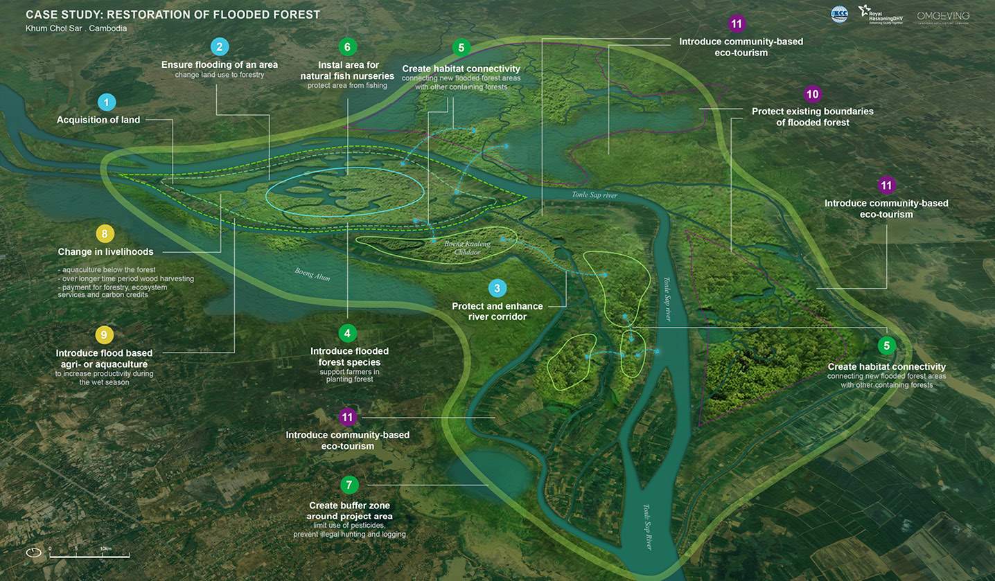
Figure. Case study for improving the flooded forest ecosystem
Improving natural floodplain dynamics with flooded forests would involve many stakeholders, including several government agencies. These stakeholders can be categorised into the following main groups:
Table. Stakeholders for flooded forest projects
Stakeholder group | Involvement |
Households | Direct beneficiaries of the project, are expected to shift their sources of income |
Private sector companies | Potential beneficiaries of the project, adjusting to new or different business opportunities |
Government organisations | Design, implementation and support of the projects |
Funders | Provide loans, funds and other forms of financing for the project |
Society | At a larger scale, social, economic and environmental co-benefits will affect society |
In addition to these stakeholders, others can be identified, such as NGOs, knowledge institutions and contractors. However, these are not expected to be the main beneficiaries or responsible for the costs of the project and hence are not included in the financial and economic analysis. Note that there could be some overlap in stakeholder groups, e.g., government organisations could fund part of the projects.