Identify areas that are threatened to deteriorate
According to Kummu and Sarkkula (2008), cumulative impact assessments suggest that dry-season water levels are expected to rise, while wet-season water levels are likely lower than the current conditions. Moreover, the Tonle Sap Lake is filled with sediment from rivers. In contrast, significant river bed incision occurs in the main branch of the Mekong, reducing the water level and thereby the duration of reversal flow into the lake. These changes in the main stem of the Mekong directly impact the flood pulse of Tonle Sap Lake and the surrounding flooded forest. Utilizing data from the Mekong River Commission, Asian Development Bank (ADB), and Adamson (2001), it is estimated that the increase in dry-season water levels could elevate the water level in Tonle Sap Lake by 0.15 – 0.6 meters, posing a potential threat to the existing lake ecosystem.
Kummu and Sarkkula (2008) used simulations to visually show potential inundation areas resulting from elevated dry-season water levels, with increments of 0.15 m, 0.3 m, and 0.6 m, as depicted in Figure below. In the Ramsar core site, covering 149 km2, the simulations suggest that 6% to 83% of the area could be affected. Similarly, within the Tonle Sap Biosphere Reserve, with a total area of 423 km2, the simulations indicate potential inundation of 13% to 42% of the total area. The key point here is that even small increases in dry-season lake water levels may lead to the permanent submersion of relatively large, flooded forest areas, possibly impacting aquatic productivity and posing a threat to the livelihoods of those dependent on the affected ecosystems, especially for the inland fishing community.
Given the scenario, it becomes crucial to initiate planning for interventions that compensate for the anticipated loss of the flooded forest.
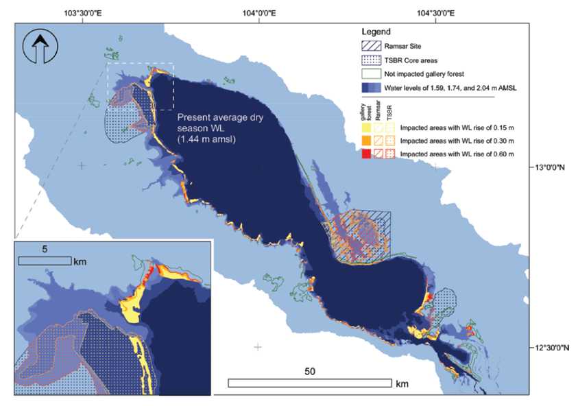
Example of impacted areas that occurred in gallery flooded forest (solid colour), Ramsar site (hatched areas in lines), and Tonle Sap Biosphere Reserve (hatched areas in points) during simulation of dry-season water level (source: Kummu and Sarkkula 2008)